 |
| Summit Lake at Stone Mountain Provincial Park |
 |
| Fog makes for careful driving |
Stone Mountain Provicial Park
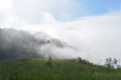
There was heavy, heavy fog, which made for some white-knuckle driving. Of course the locals, on their way to work in the oil fields or whatever, roared by in their pickup trucks. I'm sure they were somewhat irked at a slow-moving N0MAD, but I'm just not comfortable driving faster than I can see ahead.And oh, my what a day!
 |
| Reminds me of San Francisco fog! |
This section of the highway goes through the Northern Rockies. After passing through the heavy fog, the road climbed steadily and gradually broke through the fog. I stopped to look, loving the way the clouds drift down through the trees on the steep hillsides. Looking back, I could see the thick fog bank in the valley below, with mountains poking through like islands in a misty sea.
 |
| Bear crossing the road |
Summit Lake
The summit was soon reached, and there is a lovely little lake (creatively named Summit Lake) and campground. The lake is a beautiful turquoise color — not as remarkable as Grassi Lakes, but still very pretty. (I have learned that the color is because of dissolved CaCO3 from the surrounding limestone in the mountains; lakes such as these are called "marl lakes." See more info.) |
| Checkerspot butterfly |
There were quite a number of butterflies here, and also a whole garden of balanced rock sculptures. Somebody (or lots of somebodies) have been very busy! I wonder if these last through the long Canadian winter, or if they have to be rebuilt every year?
So I drank in the beauty and wrenched myself away to continue.
 |
| A perfect warm day at Muncho Lake |
Muncho Lake
i've been hearing about Mucho Lake since the Canadian border. It has a reputation for being a beautiful park. And it is. It's a long, relatively narrow clear turquoise blue lake, surrounded by mountains on all sides. It's spectacular, but, like Lake Tahoe, almost too big to comprehend or appreciated. I admit to liking smaller lakes, like Summit Lake that I'd just left.One of the interesting things about this area is the intensity of the flash flooding that periodically goes on here. The mountains are so steep, and some of the storms so intense, that incredible amounts of water come down the mountains and deposit huge amounts of material. This results in enormous alluvial fans, similar to what one sees in the desert. These flow into the lake, altering the shorelines significantly. If you look at a topographic map, you can see the fans encroaching into the lake at the bottom of each steep mountain valley.
 |
| Looking upstream through the culvert |
I also walked uphill along the Stone Sheep Trail, but did not see any wildlife. The trail is markec by cairns on either side of the wash, since any trail would just be washed away by these big flood events. Photos do not communicate the size and scale and immensity of these mountains and rivers and dry creekbeds.
 |
| Stone sheep lamb & ewe |
A comment about traffic: there is a lot of traffic on the highway, especially during the main part of the day. It's a major artery for all kinds of industrial truck traffic — big semis hauling goods of all kinds: maybe 30% of the traffic. A good 60% is RVs, trailers and campers. I've never seen SO MANY huge bus-like motorhomes, fifth-wheel trailers and smaller rigs. It's about as good as going to an RV show. The remainder of the vehicles are pickup trucks,, cars, and a surprising number of motocycles..
 |
| Traffic jam on the Alaska Highway |
The scenery through this section is magnificent. The high mountains range everywhere, some of them intensely folded, others angled at steep dipslopes.
The rivers are still rushing from yesterday's rains: the Tetsa and they are every color — the Coal River is milky gray, the Toad River is greenish (although not named for toads), and the Trout River light turquoise before joining the lazy, broad Liard River.
Liard River Hot Springs Provincial Park
Words fail. It's beautiful, well-cared for, and just a delight.There is a big "alpha pool" that collects water from about six springs uphill from the pool. The water coming from the pool is reputed to be about 36°C, and only slightly smells of sulphur, although my silver bracelet did get blackened from the waters.
Everyone enjoys the hot springs. For just $5/person, you can laze away the day there. A long (1/4 mile?) boardwalk leads across the "tropical valley" swamp to the changing room and pools. The upper pool is turquoise blue and absolutely clear. It is rimmed with plants except for the side that has cement steps into the water. The bottom of the pool is gravel (but I did wear my water shoes, since I have wimpy feet). The pool is about 3' deep.
 |
| Poutine food truck at Liard Hot Springs |
It was a perfectly lovely experience.
 After soaking my troubles away, I had dinner — ginger chicken, not poutine! — and managed to forget my sunglasses at the pool, so had to walk back to get them. They were still there exactly in the cubby where I'd left them (yaay for Canadian honesty!).
Then again regretfully left yet another beautiful place. They do have overflow camping at the campground in a lot across the highway; it was rapidly filling by late afternoon. It looked like a fun place to stay, but I needed to make some miles.
 I left about 9:45pm, and the late evening sun was problematic when driving this stretch, since some part of the highway is actually heading west and northwest. However, it was an opportunity to slow down, and by this time those 60% of those RVers are camping, not traveling.
This was really a magical drive. I saw so many animals — I know that dusk (and dawn) are good times to see wildlife, and now having had this experience, I have to agree.
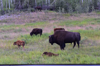
There were several herds of wood bison (bigger than our plains bison), two porcupines, several foxes and a MOOSE!! I was pretty excited to see the cow moose, standing in one of the few open spaces along the road.
Arrived in Watson Lake around midnight, and found a place to sleep.
Have been at the Watson Lake visitor center today; some travel plans may be changing, after talking with the nice ladies at the Center. But I have until Whitehorse to decide. Hopefully I'll know more of how things are going early in the week. Yukon territory is gorgeous, and there are so many things I'd love to do — there's a bird observatory to visit, lakes to kayak in, hikes to walk. I need to post this and get going. Next post probably from Whitehorse in a day or two.
No comments:
Post a Comment